**4/8/26 Advisory: The Land Trust plans to conduct a prescribed burn in early May at the Metolius Preserve. The Preserve will remain open during the burn period, but we recommend staying off the Pine Trails in the southern section of the Preserve due to smoke and burn impacts. Learn more.**
The Land Trust acquired and protected the 1,240 acre Metolius Preserve in 2003. This primarily forested property located near Camp Sherman, OR (see map below) supports mature ponderosa pine, Douglas fir, and western larch, as well as a rich diversity of other plant species. Three miles of Lake Creek, an important tributary to the Metolius River, flow through the property, contributing to the rich habitat found on the Preserve.
A columbine at the Metolius Preserve. Photo: Joan Amero.
Watch for wildlife: Numerous birds inhabit the Preserve (more than 110 species have been identified) including the white-headed woodpecker, a sensitive species. Large mammals such as elk, deer, black bears, cougars, bobcats, badgers, beavers, and otters also make their home here as do smaller mammals such as the northern flying squirrel, voles, and shrews. See the Preserve's Bird List or learn more about the butterflies of the Metolius Preserve.
Discover the story of native fish: Lake Creek, which runs through the Preserve, provides habitat for native redband trout, spring Chinook salmon and serves as a migratory route to Suttle Lake for sockeye salmon.
Explore native plants: The Metolius Preserve protects a diverse array of plants including the rare Peck’s penstemon. Join a Land Trust plant tour to learn the names of the various native plants that flourish on the Preserve such as snowberry, ocean spray, nutka rose, incense cedar, and the seasonally colorful western larch and vine maple.
The Metolius Preserve protects three miles of Lake Creek, ponderosa pine and mixed-conifer forest, and habitat for a wide variety of wildlife including native salmon, songbirds, black bear, and elk. Historically, a significant proportion of Metolius River spring chinook salmon spawned in Lake Creek, and one of Oregon’s two native sockeye salmon runs migrated through Lake Creek to Suttle Lake.
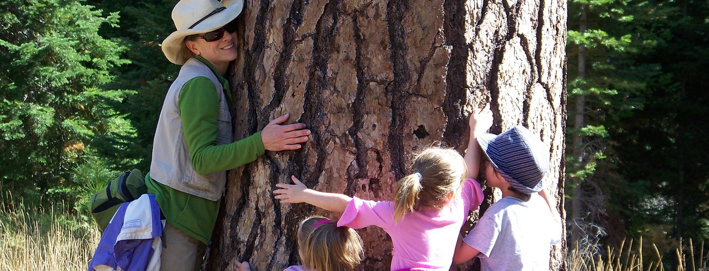
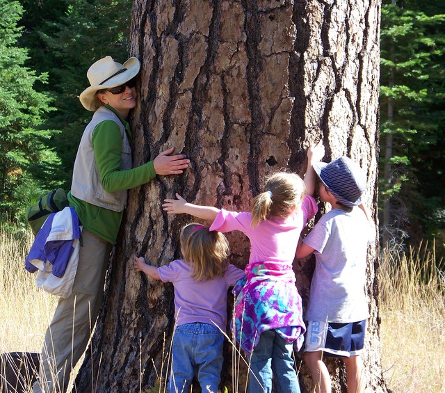
The Metolius Preserve also provides low-impact accessible recreation opportunities that allow the local community to enjoy and connect with the natural world, gain physical and mental health benefits, while also ensuring that our forests and streams remain protected and available for generations to come. Other community values include helping maintain the scenic character of the region and protecting cultural resources. Finally, the Metolius Preserve helps mitigate the impacts of climate change by helping store CO2 and by restoring and growing native vegetation that removes CO2 from the atmosphere. Land conservation is climate action, and our forest restoration efforts increase fire resiliency for surrounding communities.
Forest restoration at the Metolius Preserve. Photo: Jay Mather.
The Land Trust manages the Metolius Preserve to protect and, where necessary, restore fish and wildlife habitat. Since acquiring the Preserve in 2003, the Land Trust has completed a variety of restoration projects including:
Forest Restoration. The Land Trust's forestry efforts at the Metolius Preserve have been focused on creating a forest that is resilient to the impacts of climate change and provides healthy habitat for native plants and animals. Restoration activities include forest thinning, decommissioning old logging roads, and re-vegetation of closed areas. Learn more.
Stream restoration. In 2008, the Land Trust worked with the Upper Deschutes Watershed Council to remove a large culvert on Lake Creek to improve fish passage and habitat.
Managing weeds. Noxious weeds are a reality at all Land Trust protected lands. If they are not actively managed they compromise healthy native plant communities.
The Metolius Preserve can be accessed via two main trailheads: the North Trailhead and the South Trailhead. Both entrances to the Preserve are open to the public during daylight hours year-round.
The Metolius Preserve offers the following amenities:
Two trailheads with informational kiosks (North and South trailheads); trailside interpretive signs.
North Trailhead parking area is loose gravel with parking area for 12 cars.
South Trailhead parking area is loose gravel with parking area for 8 cars.
10+ miles of mostly flat, natural surface and loose gravel trails with variable trail widths. Trails can get muddy in the winter and spring, please avoid using them during these times. Learn more about trails and routes at the Preserve.
Trailside wooden benches.
Seasonal portable restrooms at the North and South Trailheads.
No drinking water or trash removal services and shade is variable. Cell phone reception is very limited. Snow may block access to the Preserve in the winter. Watch our video below to learn more about visiting the Preserve.
Preserve guidelines
Use of the Metolius Preserve is conditional upon following these and any other posted rules:
Dogs must be kept on leash. Please clean up after your pet.
Pedestrian and bike travel allowed on all trails.
Horse travel ONLY on Lake Creek Trail.
Stay on roads and trails and respect restrictions as posted.
Removal or disturbance of plants, wildlife, and historical artifacts is prohibited.
Follow state laws when fishing on the Preserve.
No hunting, motorized vehicles, camping, campfires, smoking, or unmanned aircraft use.
Commercial use and private events are prohibited.
Please note: the Metolius Preserve is private property owned by Deschutes Land Trust. Your use of the property is conditional upon these and any other posted rules. Preserve users failing to observe posted rules are trespassing and subject to applicable laws and penalties. Visitors to the Preserve may encounter risks associated with terrain, wildlife, and weather. Please exercise appropriate caution: the Deschutes Land Trust is not liable for injuries to Preserve visitors.
The Metolius Preserve is located west of Camp Sherman, Oregon. The map below shows the location of the Metolius Preserve along with other Land Trust conserved lands in the Camp Sherman area. The Metolius Preserve has two main trailheads: The South Trailhead and the North Trailhead. Trail maps and detailed driving directions (including mapping app links/details, GPS coordinates, and downloadable PDFs) can be found below.
Trail maps: View a trail map and route options for the Metolius Preserve (in English or en Español), or the Lake Creek Trail. You can also download a georeferenced map (in English or en Español) for use in mapping apps.
Metolius Preserve South Trailhead Driving Directions:
Mapping apps:Google Maps, Apple Maps, Waze. Important note: These mapping app links will get you to the turnoff for the unmarked Forest Service Road 2064. Do not follow your map app beyond the turnoff for FS 2064; they will not get you to the right location. Follow the rest of the written driving directions below to get to the South Trailhead.
South Trailhead Coordinates: (UTM NAD83): 603743, 4920718
South Trailhead from Sisters: Drive 10.6 miles west of Sisters on Hwy 20/126. Turn right onto unmarked Forest Service Road 2064. This is the first right turn 0.7 miles after the Camp Sherman/Metolius River turnoff. (You’ll know you’ve gone too far if the highway starts to head uphill and turns into 3 lanes.) Travel 2.6 miles on Road 2064 (red cinder road with turnoffs). You will see one large Metolius Preserve sign at ~1.75 miles: DO NOT TURN HERE. Continue straight on Road 2064, following the straight arrow on the sign. At the second Metolius Preserve sign (at 2.6 miles), turn right, following the arrow into the Preserve. Drive approximately 0.5 miles to the parking area.
Metolius Preserve North Trailhead Driving Directions:
Mapping apps:Google Maps, Apple Maps, Waze. Important note: These mapping app links will get you to the turnoff for the Metolius Preserve North Trailhead. Follow the entrance road approximately 0.25 miles to the parking area.
North Trailhead Coordinates: (UTM NAD83): 604984, 4922115
North Trailhead from Sisters: Drive 9.8 miles west of Sisters on Hwy 20/126. Take a right on Road 14 (Camp Sherman/Metolius River turnoff). Drive 2.6 miles on Road 14 until you come to a “Y.” Stay left (straight) at the “Y.” Continue on Road 1419 for another 2.2 miles until you reach a stop sign. Turn left at the stop sign onto Road 1216. Drive 1.4 miles and then take a left onto Road 600 at the large Metolius Preserve welcome sign. Drive approximately 0.25 miles to the parking area.
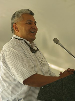
Robert Brunoe, General Manager of Natural Resources and Tribal Historic Preservation Officer for the Confederated Tribes of Warm Springs, speaks at the 2003 dedication of the Metolius Preserve. Photo: Chip Belden.
From time immemorial, Native Americans, including the Warm Springs, Wasq'u (Wasco), and Paiute tribes, lived in this region or visited it to hunt, fish, gather foods, and trade. The Metolius Preserve is within the lands ceded to the United States in the Treaty with the Tribes of Middle Oregon in 1855. The bands that signed the 1855 Treaty moved onto to the Warm Springs Reservation and are known as the Wasq'u (Wasco) and Warm Springs tribes. Paiute people began settling on the Warm Springs Reservation in 1879 and, along with the Wasq'u (Wasco) and Warm Springs tribes, now comprise the Confederated Tribes of the Warm Springs Reservation of Oregon. The Confederated Tribes of Warm Springs, by virtue of the Treaty of 1855, have legal rights to harvest and manage wildlife and, by implication, the right to habitats suitable to support wildlife populations. The Land Trust considers the Confederated Tribes of Warm Springs an important partner in management and restoration of the property.
The first Euro-Americans began to arrive in Central Oregon in the 1800s as trappers, explorers, and survey crews began mapping the region. In 1843 westward migration began along the Oregon Trail as the federal government forcibly re-settled Native Americans and offered western lands to Euro-Americans. The first record of Europeans in the Metolius came in December of 1843 when General John Fremont forded the river at a site now occupied by Pioneer Ford campground.
Brooks-Scanlon, Inc. owned the property from about 1920 to 1978, when Diamond International Corporation bought Brooks-Scanlon. In 1980, Cavenham Forest Industries purchased Diamond, and managed the property until 1988, when Crown Pacific purchased the property. Soon thereafter, Crown sold the property to Willamette Industries, who managed the property from 1988 to 2002. In the spring of 2002, Weyerhaeuser acquired Willamette Industries. In 2002, Willamette Industries granted the Land Trust the option to purchase the 1,240 acres that is now the Metolius Preserve.
Thanks to the help of many generous donors, the Land Trust was able to raise the 2.6 million dollars needed to purchase and establish the Preserve in 2003.
 A columbine at the Metolius Preserve. Photo: Joan Amero.
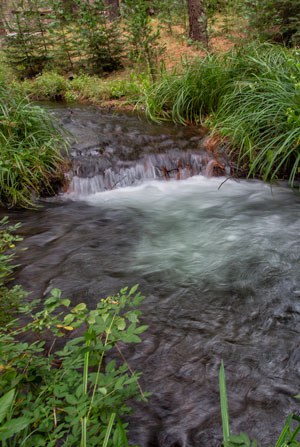 The South Fork of Lake Creek. Photo: Jay Mather.
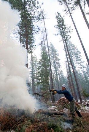 Forest restoration at the Metolius Preserve. Photo: Jay Mather.
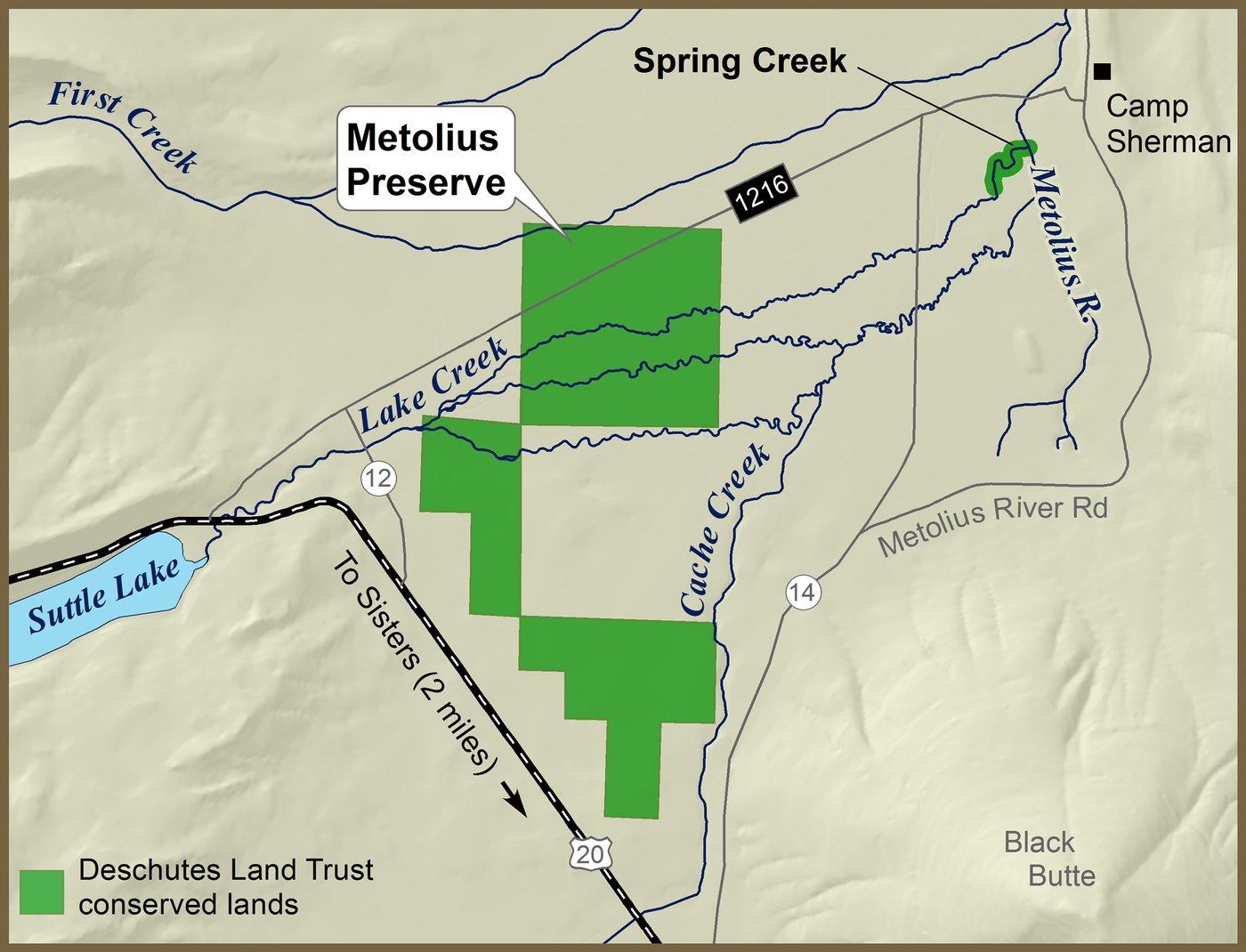
 Robert Brunoe, General Manager of Natural Resources and Tribal Historic Preservation Officer for the Confederated Tribes of Warm Springs, speaks at the 2003 dedication of the Metolius Preserve. Photo: Chip Belden.